Landmark_reference_pt_dist
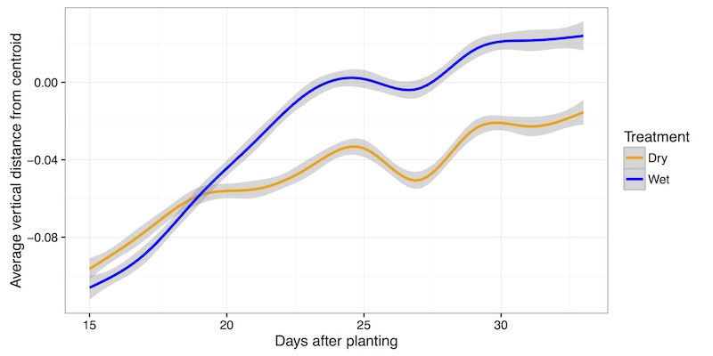
This is a function to measure the distance from user defined points to the centroid and a point defined by the centroid coordinate along the x-axis and baseline coordinate (top of pot) along the y-axis. Calculating the vertical distance between leaf tip points to the centroid of the plant object in side-view images may provide a proxy measure of turgor pressure.
landmark_reference_pt_dist(points_rescaled, centroid_rescaled, baseline_rescaled, device, debug=None)
returns device, ave_vertical_distance_from_centroid, ave_horizontal_distance_from_centroid, ave_euclidean_distance_from_centroid, average_angle_between_landmark_point_and_centroid, ave_vertical_distance_from_baseline, ave_horizontal_distance_from_baseline, ave_euclidean_distance_from_baseline, average_angle_between_landmark_point_and_baseline
- Parameters:
- points_rescaled - A list of tuples representing rescaled landmark points
- centroid_scaled - A tuple representing the rescaled centroid point
- baseline_rescaled - A tuple representing the rescaled baseline point
- device - Counter for image processing steps
- debug- None, "print", or "plot". Print = save to file, Plot = print to screen. Default = None
- Context:
- Used to estimate the distance and angles of landmark points relative to shape reference landmarks (centroid and pot height aka baseline)
Input rescaled points, centroid and baseline points

import plantcv as pcv

device = 1

# Identify acute vertices (tip points) of an object
# Results in set of point values that may indicate tip points
device, vert_ave_c, hori_ave_c, euc_ave_c, ang_ave_c, vert_ave_b, hori_ave_b, euc_ave_b, ang_ave_b = pcv.landmark_reference_pt_dist(points_r, centroid_r, bline_r, device)
Representation of many data points collected in two treatment blocks throughout time